Orienteering maps and symbols
Beginners essentials
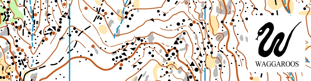
1. Bush orienteering map legend [click here]
2. Sprint orienteering map legend [click here]
3. The ‘control descriptions legend’ [click here] which explains the black & white ‘clue sheet’ used for each course. The ‘clues’ specify the code number for the control you are looking for and the physical features nearby (e.g. ‘foot of western rock face’, or ‘north side of 2m termite mound’). Since covid, clue sheets are often online before the event and you are expected to print your own. However, sometimes clue sheets might only be given out 2 mins prior to the Start of an event.
4. The O-Map Wiki website set up for mappers is actually a great place for beginners to learn through photographs and map snippets how the features you encounter out on the ground can be represented on a piece of paper.
Eventor your go-to for ‘when/where/how’ for every event in Australia, is where each event Organiser supplies the map details needed for an event plus other information (e.g. map scales, special legend items, terrain tips from the course planner, clothing advice, what’s different/special for that day).
IMPORTANTLY, maps can go out of date very quickly! Especially urban maps. ALWAYS check your map for the date of its latest upgrade – it might not be you having a bad-hair day, it might be in a few cases that the map has not been updated near where you are.
- Updates to a map occur typically during preparation for an event (say because a Council has revamped a playground).
- The International Orienteering Federation (IOF) may periodically change its specifications for some symbols to improve readability, but a club might only update the map symbols if the status of the event demands it (e.g. for state/national Championship events). As most local maps are made by orienteers who volunteer their time, the burden can be considerable to constantly keep all maps up to date.
Standards: Are you into technical details? Orienteering Australia is an active member of the International Orienteering Federation. The IOF periodically issues highly technical map specifications:
- ‘Bush’ maps use the International Specification for Orienteering Maps coding (ISOM). The latest version is ISOM 2017-2 (adjusted January 2019)
- ‘Sprint’ maps use the International Specification for Sprint Orienteering Maps coding (ISSprOM). The latest version is ISSprOM 2019-2 (updated January 2022)
- Notably, these codes offer a limited number of regional adaptations for features e.g. termite mounds in Australia
- An O-Map Wiki has been set up by the IOF to aid mappers, but it is also an interesting place to browse
- Adrian Uppill, an Australia orienteer, is on the IOF Mapping Committee and is campaigning to have better colour-coding to ensure that colour vision impaired persons are not as impacted by poor colouration as in the past (see one scientific study “Orienteers with poor colour vision require more than cunning running” by Garingal orienteer Barbara Junghans).
Who makes orienteering maps? Orienteers! Originally maps were hand-drawn on sheets of drafting film, with a separate sheet for each colour, and sent for offset printing. Base maps were obtained from local councils, or if necessary, aerial flights were commissioned to capture stereo-photographs for the one or two orienteers who owned stereo-plotters to visualise and draw by hand the contours and any visible ground features using a pantograph. Thereafter, an orienteer would go out into the field with a section of the base map on a clipboard, a set of coloured pencils and a rubber. Pretty well every square metre of ground would be covered and details pencilled in. At night, they would put the field work under the master drafting film and add every feature and contour modification using a light-table.
However, now the base maps are extracted digitally from LIDAR geo-data which the government has from aerial surveys using digital cameras. ONSW has an arrangement to access LIDAR data or aerial photographs from NearMap for ‘not-for-profit’ pricing. This reduces the cost of obtaining a base map to ~5% what it used to be. However, the fieldwork still takes considerable time. And these findings have to be added onto the base map on the computer. The most commonly used software is OCAD®. But a free open-source software Open Orienteering Mapper also works well. Many areas are suitable to use GPS tracking, but the vagaries of GPS tracking must be well understood to ensure accuracy making an O map. The IOF has a tutorial on how to make a map.
How are the courses put on the map? Normally the Course Planner does this. OCAD can be used, but Australian’s will frequently use Purple Pen freeware because the map can be simply acquired as a PDF, and, the software is quicker to learn.
Equipment
You don’t need a lot of gear to go orienteering. Here are a few things that can help you achieve your best performance or make the journey a little more comfortable. You won’t need all of these things for your first event and you can usually hire or borrow the SportIdent stick and compass.
If the event is using the MapRun app, you will need a smartphone with the app installed, or a Bluetooth enabled, compatible smartwatch. Ensure your battery is fully charged, you have access to data, GPS location is turned ON, and any power saving settings are OFF. Visit https://maprunners.weebly.com/ for more information.
Bush events:
- Protective running clothes (usually including lightweight gaiters you can move quickly in, and shoes with “grippy” soles and good toe protection)
- Sportident stick – hire sticks will be available at all events
- Compass – available for loan if you don’t have your own
- Control sheet holder (Optional)
- Watch or runners’ GPS (not handheld units) (Optional)
- Water bottle or hydration pack (Optional but recommended for longer events and/or in warmer weather)
Park and street events:
- comfortable running clothes/shoes
- watch/GPS/phone to tell how much time you have left
- torch/head torch (for night events)
- water bottle (post run or extra long events)
Sprint events:
- Normal running clothes or active wear
- SportIdent stick – hire sticks will be available at all events
- Compass – available for loan if you don’t have your own
- Watch or runners’ GPS (not handheld units) (Optional)
- Control sheet holder (Optional)
